The New Era of Extreme Weather: When Normal Becomes Abnormal
Climate change has fundamentally altered the global weather system, turning once-rare events into regular occurrences. The past decade has seen a 40% increase in the frequency of extreme weather events compared to the 1980s, according to the World Meteorological Organization. Hurricanes now intensify faster, heatwaves last longer, and precipitation patterns have become erratic.
Meteorologists attribute this shift to three primary factors: rising global temperatures, disrupted atmospheric circulation, and melting polar ice caps. Warmer oceans fuel stronger storms—Hurricane Ian (2022) gained Category 4 status in just 36 hours, leaving communities with minimal evacuation time. Meanwhile, heat domes like the Pacific Northwest's 2021 event shattered temperature records by 10-15°F, overwhelming emergency services.
These changes strain traditional forecasting models. Historical weather patterns no longer reliably predict future conditions, forcing meteorologists to adopt probabilistic approaches. The European Centre for Medium-Range Weather Forecasts now runs ensemble models with 51 different simulations to capture uncertainty ranges, a process requiring supercomputing power that was unimaginable two decades ago.
Radar Evolution: From Analog Dials to AI-Powered Super-Scanners
Modern meteorological radar has undergone a technological revolution to keep pace with climate-driven extremes. Traditional Doppler radars, which measure precipitation velocity, have been upgraded to dual-polarization systems capable of distinguishing rain, snow, sleet, and hail. The U.S. National Weather Service completed its nationwide dual-pol upgrade in 2013, improving tornado warning lead times by 14 minutes on average.
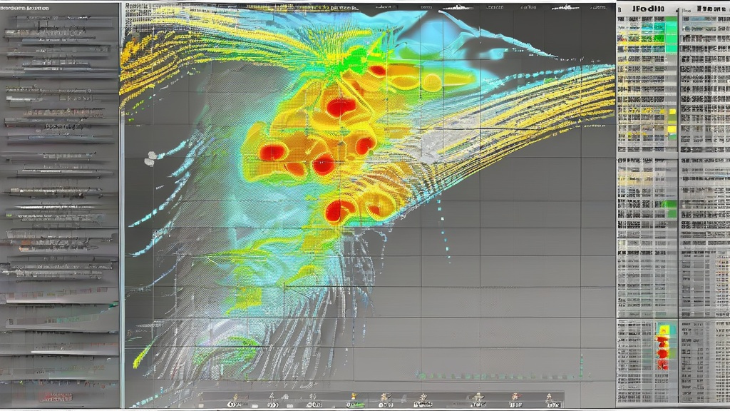
The latest innovation is phased-array radar, which uses electronic beam steering to scan the atmosphere 6-10 times faster than mechanical dishes. Lockheed Martin's Multi-Function Phased Array Radar (MPAR) can track multiple weather phenomena simultaneously while detecting aircraft—a critical capability as air traffic increases. During Hurricane Harvey (2017), experimental phased-array systems provided 22-minute lead times for flash flooding in Houston, compared to 8 minutes from conventional radars.
Artificial intelligence now augments radar data interpretation. Google's TensorFlow-based models analyze radar mosaics to identify storm cell formation patterns, reducing false alarms by 37% in pilot programs. The National Oceanic and Atmospheric Administration (NOAA) is integrating machine learning with radar networks to create "nowcasting" systems that predict severe weather impacts at street-level resolution.
Case Studies: When Radar Saved Lives (and Where It Fell Short)
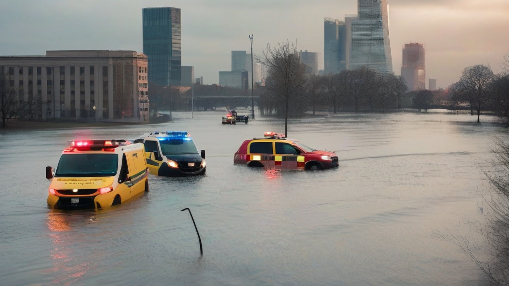
The 2021 European floods demonstrated both radar's capabilities and limitations. Germany's DWD meteorological service issued warnings 36 hours before record rainfall, but outdated flood maps and communication breakdowns caused 184 deaths. Conversely, Japan's X-band phased-array radar network provided 90-minute warnings during Typhoon Hagibis (2019), enabling evacuation of 1.1 million people with only 98 fatalities despite catastrophic damage.
In the U.S., the 2022 Kentucky tornado outbreak revealed gaps in rural radar coverage. The Jackson, Mississippi NEXRAD station's 140-mile range left western Kentucky in a "radar shadow," delaying tornado warnings by 12 critical minutes. This prompted Congress to allocate $187 million for 165 new X-band radars to fill coverage gaps, particularly in Tornado Alley.
The most promising development is gap-filling radars like the University of Massachusetts' C-band system, which uses solar power and satellite uplinks to operate in remote areas. Deployed in Alaska's Yukon Delta since 2020, these units have improved flood forecasting accuracy by 62% in regions previously reliant on satellite estimates with 6-hour delays.
The Future: Quantum Radar and Hyperlocal Forecasting
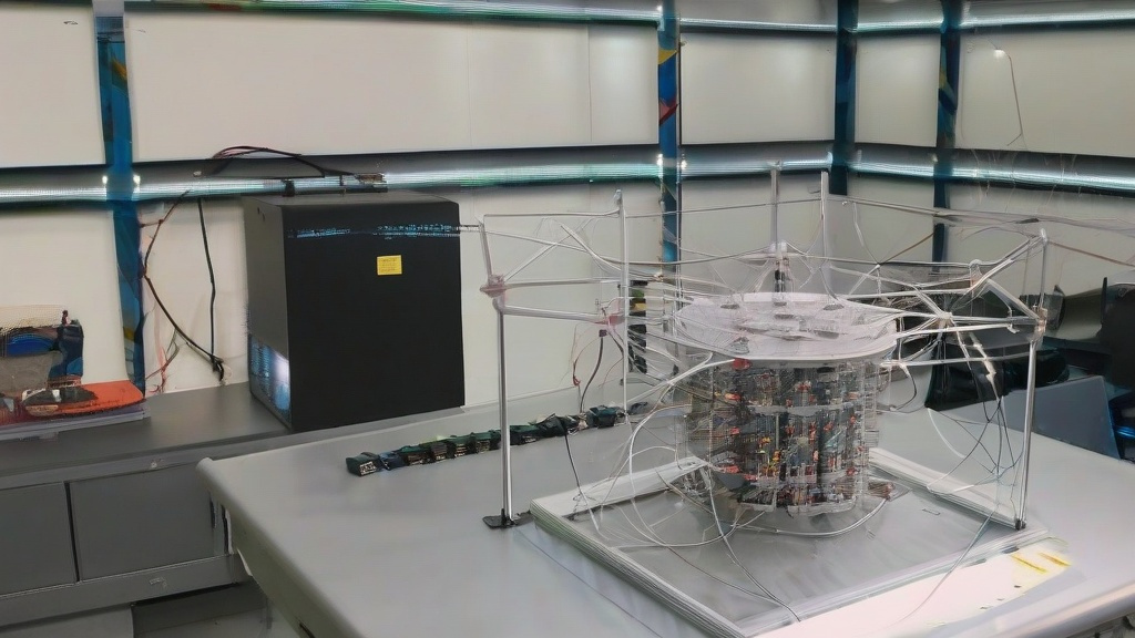
Emerging technologies promise to revolutionize weather observation yet again. Quantum radar, still in laboratory testing, uses entangled photons to detect atmospheric particles with unprecedented sensitivity. MIT researchers claim their prototype can identify raindrop sizes 100x smaller than current systems, potentially enabling 30-minute precipitation forecasts.
On the software side, NOAA's Earth Prediction Innovation Center is developing a unified modeling system that integrates radar, satellite, drone, and crowd-sourced data. Scheduled for 2025 deployment, this "digital twin" of Earth's atmosphere aims to provide 15-minute hyperlocal forecasts—critical for urban heatwave responses and wildfire smoke dispersion tracking.
The ultimate challenge lies in making this data actionable. Cities like Miami are piloting AI-powered warning systems that send targeted alerts based on real-time radar data. When Hurricane Irma approached in 2017, the system's prototype reduced unnecessary evacuations by 43% while ensuring high-risk zones received prioritized alerts.